Brewerton & Oneida Lake (West)
Approx. Mile 140–160 along the Erie Canal
Barge Canal · 1918 — Oneida Lake’s west end, entering the canalized Oneida River. Which canal is this? →
Brewerton sits at the west end of Oneida Lake, where the big water pinches back down into the Oneida River and the canal resumes locked navigation at Lock E23, the first lock on the west side of the lake and traditionally one of the busiest on the whole system. It is a working boating hub — anchored by the large, full-service Ess-Kay Yards — layered over frontier history at the site of Fort Brewerton, established in 1759 during the French and Indian War.
Just past the section's western edge lies Three Rivers Point (Mile ~160), where the Oneida, Oswego, and Seneca Rivers meet. This is the great fork of the western canal: north up the Oswego Canal toward Lake Ontario, or southwest on the Erie mainline toward Buffalo. Whichever way you are headed, Brewerton is the place to catch your breath.
The fort at the lake’s gate
Oneida Lake is a wide, shallow inconvenience — twenty-one miles of open water dropped squarely across the route between the Hudson and the Great Lakes. For every army, trader, and canal boat that ever crossed it, the lake had exactly two doors: the beach at the eastern end, and, twenty-one miles west, the narrow outlet at Brewerton where all that water drains back into a single river. Hold the western door and you hold the road to the interior. That is why, two centuries before pleasure boats began tying up here, soldiers built a fort on this ground.
The route mattered because of what lay beyond it. From the Mohawk River a traveler could work west and north through Oneida Lake and down the Oswego River to Lake Ontario — the great water highway between Albany and the British post at Oswego, and the supply line on which control of the frontier depended. In 1759, during the French and Indian War, British and provincial forces raised Fort Brewerton at the lake’s western outlet to command that passage. It was no simple stockade. The fort was laid out as an eight-pointed star earthwork — sixteen faces, each about thirty feet long, thrown up in packed earth and ringed by a moat roughly ten feet across. The unusual geometry was the point: a star’s projecting angles let defenders rake every approach with crossfire, leaving no blind wall for an attacker to hug. Manned by a garrison of well over a hundred, it guarded the outlet through the war’s dangerous middle years.
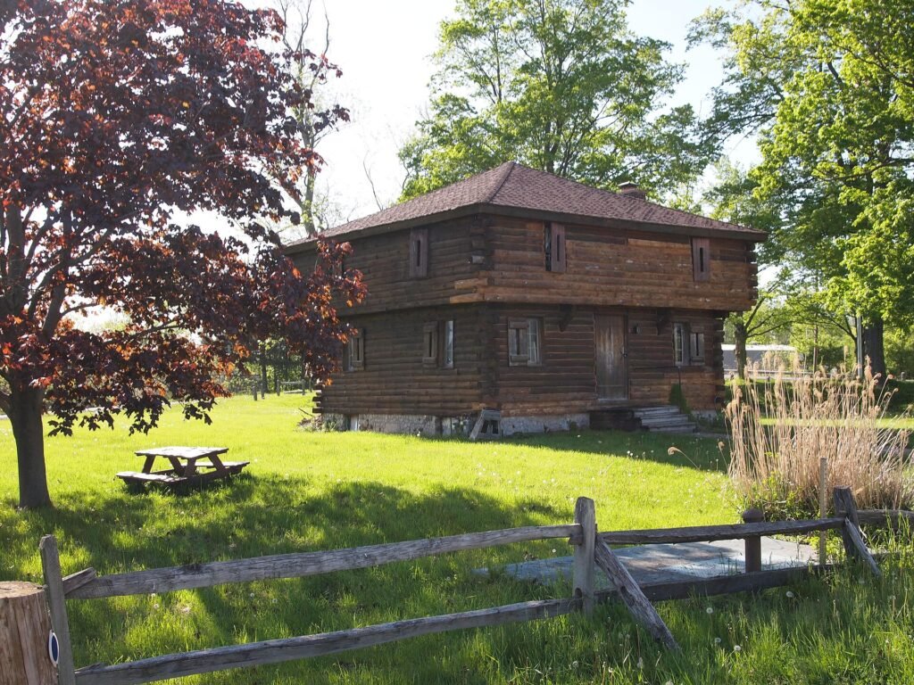
The fort’s active life was short — the frontier moved on, and the earthworks softened back into the ground — but the site kept its human thread. In 1789, a settler named Oliver Stevens made his home on the old fort grounds, living in one of its blockhouses and running a trading post and a tavern for the boatmen already using the outlet as a natural stopping point. His name is the one Brewerton still keeps: the Oliver Stevens Blockhouse Museum, its reconstructed blockhouse completed in 1978, holds the memory of both the star fort and the frontier settlement that outlasted it. (One threadbare piece of local color — a claim that Alexis de Tocqueville lingered by these shores in 1831 — is best treated as legend until someone pins it down.)
Geography made Brewerton a place of passage, and it has never stopped being one. Where the lake pinches shut, the open water gives way to the canalized Oneida River, and the Erie resumes locked navigation at Lock E23 — for generations counted among the busiest locks on the whole system, because everything crossing the lake had to funnel through it. Push a few miles farther west and the river reaches Three Rivers Point, the fork that decides a journey: here the Oneida meets the Seneca, and the two join to form the Oswego, the northward branch toward Lake Ontario — while the Erie mainline bends off southwest toward Buffalo. It is the same choice that made the outlet worth fortifying in 1759: north to the lake, or west to the interior. If you are unsure which waterway carries you today, the guide to that is here; if you have just crossed from the far shore, that story begins at Sylvan Beach. Long a fishing and boating hub, Brewerton still does what its fort was built to do — watch the gate where the lake lets go of the water.
In this stretch
Places to Eat
Provisions & Shops
Things to see & do
Arriving by boat
For boaters, Brewerton is above all a staging and fuel stop — the deep water and full services at the west end of the lake make it the natural place to top off before an eastbound Oneida Lake crossing, or to lick your wounds and refuel after one. Lock E23 (6908 Black Creek Rd) sits on the Oneida River at roughly Mile 153.65; a guard gate and four bridges with a controlling vertical clearance of 21.7 ft precede it.
The marquee stop is Ess-Kay Yards, one of the most complete marinas on the entire canal — a large full-service yard founded in 1972, with a 70-ton haul-out and room for vessels up to about 110 feet. Approach and dockside depths run roughly 15 and 12 feet, its fuel dock carries non-ethanol gas and diesel, and it monitors VHF 16 (working channel 9). A short way west near Central Square, Winter Harbor Marina offers about 28 transient slips, handles boats to roughly 150 feet in some 12 feet of water, monitors VHF 16 (working 9), and runs a 24-hour credit-card non-ethanol gas dock — handy for off-hours arrivals.
Several other Brewerton-area marinas — including Brewerton Boat Yard, Aero Marina, Winds of Cold Springs Harbor, and J&S Marine — round out one of the densest clusters of services on the canal. Confirm slip availability, current fuel, and pump-out in season before you count on them.
By paddle
Public launches at the west end of the lake include Brewerton itself and Oneida Shores County Park, which has a paved launch (fee). The same big-water advisory that governs the eastern shore applies here: Oneida Lake is shallow and can build a steep, ugly chop with startling speed, so check the wind and wave forecast, hug the shoreline, and do not commit to open water on a doubtful day.
By car
By car, Brewerton's history and its waterfront are both easy to reach. The Fort Brewerton site and Oliver Stevens Blockhouse Museum is a drive-in historic stop, and Oneida Shores County Park offers a lakefront beach, boat launch, and parking (fee). Waterfront restaurants line the US-11 corridor, most with their own lots.
Where to eat
Brewerton eats with a view of the water. The Waterfront Tavern (6 US Rt 11, Central Square) is a full bar and restaurant with outdoor dining over Oneida Lake — steaks, seafood, burgers, and live music. The Waterfront Dockside is a lakeside bar and grill in Brewerton, and Barado's on the Water serves from outdoor seating out over the lake, voted #1 for Outdoor/Waterfront Dining in the 2024 Syracuse Readers' Choice. Confirm current hours in season.
What to see
The centerpiece is the Fort Brewerton site and Oliver Stevens Blockhouse Museum (Fort Brewerton Historical Society), where a reconstructed blockhouse — completed in 1978 — anchors exhibits spanning ten thousand years of local history, from Native American materials to military artifacts to eighteenth-century frontier life. The fort itself dates to 1759, guarding the water route between the Great Lakes and Albany, and in 1789 Oliver Stevens settled here to run a trading post and boatman's tavern.
On the water, Lock E23 rewards a look as one of the historically busiest locks on the canal, and just west, Three Rivers Point marks the Oneida–Oswego–Seneca confluence where the Oswego Canal branches off toward Lake Ontario. Oneida Shores County Park rounds out the section with beach and lakefront recreation.