Montezuma & the Cayuga–Seneca Junction
Approx. Mile 195–205 along the Erie Canal
Barge Canal · 1918 — the canalized Seneca River through the drained Montezuma marshes. Which canal is this? →
West of Baldwinsville the canal slips into the Seneca River and the low, marshy heart of the corridor — a reach that rewards patience and a good pair of binoculars more than a full-service marina. Here the Cayuga–Seneca Canal branches south toward Cayuga and Seneca Lakes, making the water near May's Point the eastern gateway to the Finger Lakes and one of the great junctions of the whole system. Around it spreads the Montezuma National Wildlife Refuge, roughly 10,000 acres of open water and cattail marsh that is the drowned remnant of the old Montezuma Marsh, and — half-hidden in the reeds — the stone ruins of the Richmond Aqueduct, which once carried the Enlarged Erie Canal clear over the river.
Be honest with yourself about what this stretch is: a passage-and-nature reach, not a provisioning stop. Services are limited, the scenery is wide and quiet, and the real event is the birdlife and the fork in the water where the Finger Lakes begin.
The marsh that dug back
Somewhere under the reeds and open water of the Montezuma National Wildlife Refuge lies the deadliest ground the original Erie Canal ever crossed. When the diggers reached this place in the early 1820s, it was not the placid refuge you see today but the Montezuma Marsh — a vast, drowned expanse at the outlet of Cayuga Lake, the kind of wetland that swallowed roads, wagons, and, according to the stories that have clung to it ever since, men.
The killer was invisible. Crews working the marsh began falling ill with what they called “Montezuma Fever” — chills, sweats, and collapse — almost certainly malaria, carried by the clouds of mosquitoes that bred in the standing water. Nobody in the 1820s understood the connection; the link between mosquitoes and malaria would not be proven until the very end of the nineteenth century. The builders only knew that the swamp made men sick, and that the summer season was the worst of it. Their answer was grim and effective: they waited for winter. The cut through the marsh was finished in the cold months, when a hard frost silenced the insects — though the diggers then traded fever for frostbite, working the frozen muck in bitter conditions to close the last gap in the ditch.
How many died here is where history hardens into legend. A figure of more than a thousand dead has trailed the Montezuma section for two centuries, repeated in guidebook after guidebook. Treat it with caution: there is no contemporary payroll, no mass grave, no primary record that supports a toll anywhere near that number, and modern researchers regard the figure as folklore rather than fact. That the digging was murderous is beyond dispute; the round, dramatic number is not. The marsh earned its dark reputation honestly — but the specific body count belongs to the realm of the story, not the ledger.
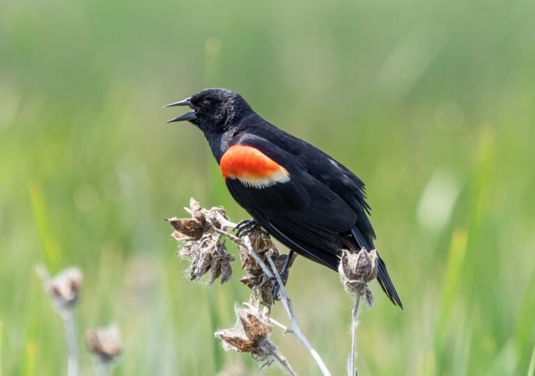
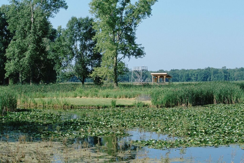
The marsh that killed those men no longer exists in the form they knew. It was undone not by draining ditches but by a single decision downstream: when the Barge Canal was built in the early twentieth century, engineers put a lock at the north end of Cayuga Lake and a dam at the lake’s outlet. That work lowered the level of the river through here by eight to ten feet — and as the water dropped, the great marsh simply drained off the land. What survived became the Montezuma National Wildlife Refuge, established by executive order of Franklin D. Roosevelt on September 12, 1938 — first as the Montezuma Migratory Bird Refuge. Today its roughly 10,000 acres of pools and channels host more than 300 bird species, nesting bald eagles among them, as one of the great stopovers on the Atlantic Flyway. The wetland that once spread malaria is now one of the finest places in New York to watch migrating waterfowl.
The canal you travel here is younger than the fever story. Boaters today follow the canalized Seneca River — the Barge Canal running in the riverbed itself — and just to the west the Cayuga–Seneca Canal branches south, the gateway toward Seneca Falls and the Finger Lakes that opened in 1828. But the older canal has not vanished entirely. Near Montezuma Heritage Park stand the stone arches of the Richmond Aqueduct, where the Enlarged Erie once vaulted straight over the Seneca River. Designed under State Engineer Van Rensselaer Richmond, it was a masterwork: thirty-one stone arches carrying the towpath across some 840 feet of water, built between 1849 and 1857. It became obsolete in 1917, when the Barge Canal made the river itself navigable and part of the aqueduct was torn down to give boats a clear run. Seven arches still stand on the east shore and three on the west — a ruin marking the exact spot where the old canal chose to fly over the water that the new canal simply moved into. Two engineering ages, one river, and beneath it all a marsh that took its toll before it was finally put to rest.
In this stretch
Provisions & Shops
Things to see & do
Arriving by boat
Heading west on the Erie, you pass a triangular island near the confluence of the Seneca and Clyde rivers that marks the junction with the Cayuga–Seneca Canal; from there it is roughly two miles farther west to Lock E25 (May's Point), a modest 6-foot lift. To make for the Finger Lakes, turn south at the junction onto the Cayuga–Seneca branch, whose first lock down is CS-1, "Mud Lock," lifting boats up to the level of Cayuga Lake. Erie Canal mileage runs continuously through this reach; Cayuga–Seneca mileage begins at zero at the junction and runs about twenty miles south.
This is thin water for amenities. Waterway Guide lists a free dock at Lock E25, but confirm amenities in season — we have not verified fuel, pump-out, controlling depth, or anchorages for this specific reach, so plan to arrive self-sufficient rather than counting on services here. For lock working channels, treat VHF as a confirm-in-season item. Just off the Clyde River near May's Point, Rivers Crossing Campground & Marina in Savannah offers 30 slips (about $15/day for registered guests), a boat launch (about $10/boat), trailer storage, and a stocked store carrying bait, ice, food, and propane — a genuinely useful resupply, with the original hand-dug 1817–25 canal running right through the grounds.
By bike & foot
The Empire State Trail / Erie Canalway Trail threads this corridor, and the Port Byron–Camillus segment just east of Montezuma is one of the good ones — about 20 miles, 18 of them off-road stonedust. A 12-mile Cayuga County stretch links Montezuma, Port Byron, and Weedsport as designated Trail Towns, with dining and services on or near the path.
Set expectations near the junction, though: there are notable on-road gaps between Clyde and Port Byron, and riders bound south for Seneca Falls leave the Canalway Trail for rolling back roads, so plan for some road miles. For a shorter, atmospheric walk, Montezuma Heritage Park (8098 High Street, Montezuma) carries the Byron Lapp Memorial Trail along the original enlarged-Erie towpath to the Richmond Aqueduct ruins — swampy ground that can run muddy or flooded in spring.
By paddle
Rivers Crossing Campground & Marina offers a boat launch and canoe and kayak rentals on the Clyde River within the Montezuma complex — a natural put-in for exploring the surrounding water. An Erie Canalway paddling itinerary notes a kayak dock and concrete ramp near Lock E25 for an easy takeout; confirm in season.
One firm rule shapes any paddle here: canoeing and kayaking are allowed on the Seneca River, the Clyde River, and the Barge/Erie Canal, but not within the Montezuma refuge itself. Paddlers moving through the reach will need to lock through or portage at E25 and Mud Lock (CS-1); specific portage paths are not documented here, so scout before you commit.
By car
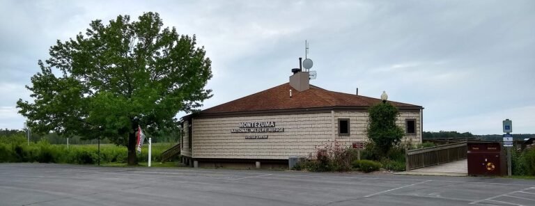
By car the headline is the Montezuma NWR Visitor Center and 3.5-mile Wildlife Drive, an auto loop with "guide by cell" stops and radio narration, open April 1–November 30 (Visitor Center 10am–3pm, weather permitting). It is the easiest way to sample the refuge without a boat or a long walk.
Montezuma Heritage Park at 8098 High Street offers parking and trail access to the Richmond Aqueduct ruins. The refuge sits within reach of the NYS Thruway, Routes 5 & 20, and Route 89 near Seneca Falls.
Where to eat
The standout is Montezuma Winery & Hidden Marsh Distillery at 2981 US-20 in Seneca Falls, minutes from the refuge. The kitchen runs Thursday–Sunday, 10am–5pm, with naan pizzas, paninis, and charcuterie alongside tastings, cocktails, and wine slushies. Beyond that, the Seneca Falls area and the Port Byron and Weedsport Trail Towns add farm-to-table spots, breweries, and coffee shops along the trail — worth a look, though we'd confirm hours and specifics before building a day around any one of them.
Where to sleep
On the water, Rivers Crossing Campground & Marina in Savannah is the obvious base — a 46-acre waterfront campground with RV and tent sites, a pool, showers, laundry, and a store, set on the historic Clinton's Ditch beside the refuge. Rates and availability shift with the season, so confirm before you count on a site. For chain hotels, the nearest cluster is over in the Seneca Falls, Waterloo, and Auburn area.
What to see
The Montezuma National Wildlife Refuge anchors the reach — roughly 10,000 acres, 300-plus bird species, nesting bald eagles, and a major Atlantic Flyway stopover that turns spring and fall into spectacle. Nearby stand the Richmond Aqueduct ruins: a 31-arch, roughly 894-foot stone aqueduct built 1849–1857 to carry the Enlarged Erie over the Seneca River, the second largest on the enlarged canal, with about seven arches surviving on the east shore and three on the west, visible from Montezuma Heritage Park.
The whole junction is preserved as the Seneca River Crossing Canals Historic District (listed on the National Register in 2005), which holds the enlarged-Erie prism, towpath, a drydock, the aqueduct remains, and traces of the original 1817–25 canal, including Lock #62. And the Cayuga–Seneca Canal branch itself is the attraction for many boaters — the gateway south toward Seneca Falls, Waterloo, and the Finger Lakes.