Spencerport & Brockport
Approx. Mile 265–290 along the Erie Canal
Barge Canal · the Long Level — 64 lock-free miles; lift-bridge country. Which canal is this? →
West of Rochester the Erie Canal settles into its most celebrated stretch: the Long Level, roughly sixty lock-free miles where the water rises only about two feet the whole way to Lockport. For a boater it means an uninterrupted glide, engine ticking over, nothing to lock through until the far western end. The classic stops along here are Spencerport, Adams Basin, and Brockport — walkable villages whose downtowns still pivot on their working lift bridges.
Brockport bills itself "the Victorian Village on the Erie Canal," and it earns the tagline with a Main Street of nineteenth-century storefronts, the SUNY Brockport campus a few blocks off the water, and a newer pedestrian bridge stitching the two banks together. Both villages keep free canal-wall docking and welcome centers, which makes this reach one of the most forgiving on the whole system for tying up and stepping ashore.
The sixty-mile drift
West of Rochester the Erie Canal does something it does nowhere else: it stops climbing and simply keeps going. For roughly sixty-four miles — from the Rochester area to Lockport — the water lies dead flat, rising only about two feet across the entire reach, and in all that distance a boat passes through not a single lock. Canal people call it the Long Level, or the “sixty-mile level,” and it is the longest lock-free stretch on the whole waterway. On a canal defined elsewhere by the drama of the lift — the five hard steps at Waterford, the forty-foot gorge at Little Falls — this is the opposite kind of marvel: sixty miles of doing nothing at all, on purpose.
The flatness is not luck; it is geography the canal was clever enough to use. Between the Genesee River and the western edge of the state lies a broad, low plain — the old lake bottom left along the southern shore of Lake Ontario, hemmed to the south by the Niagara Escarpment, the same limestone ledge that Niagara Falls pours over. Ride the top of that plain and the land barely tilts. The canal’s surveyors, hunting the cheapest possible line, found they could run the channel clear across western New York without stepping the water up or down — because locks were slow and expensive, and every one avoided was money saved and time gained. So they let the level run, and ran it, and ran it, until the plain finally gave out at Lockport, where the escarpment forced the reckoning the whole Long Level had postponed: the climb over the rock wall to Lake Erie.
Contemporaries understood they had built something singular. Early accounts counted two great “long levels” on the finished canal — one of about seventy miles across the middle of the state, and this western one of some sixty-five — and described them, together, as the two longest canal levels in the world, comprising more than a third of the canal’s entire length. The western level was among the first stretches proven navigable, precisely because the easy ground let the diggers move fast.
Lift-bridge country
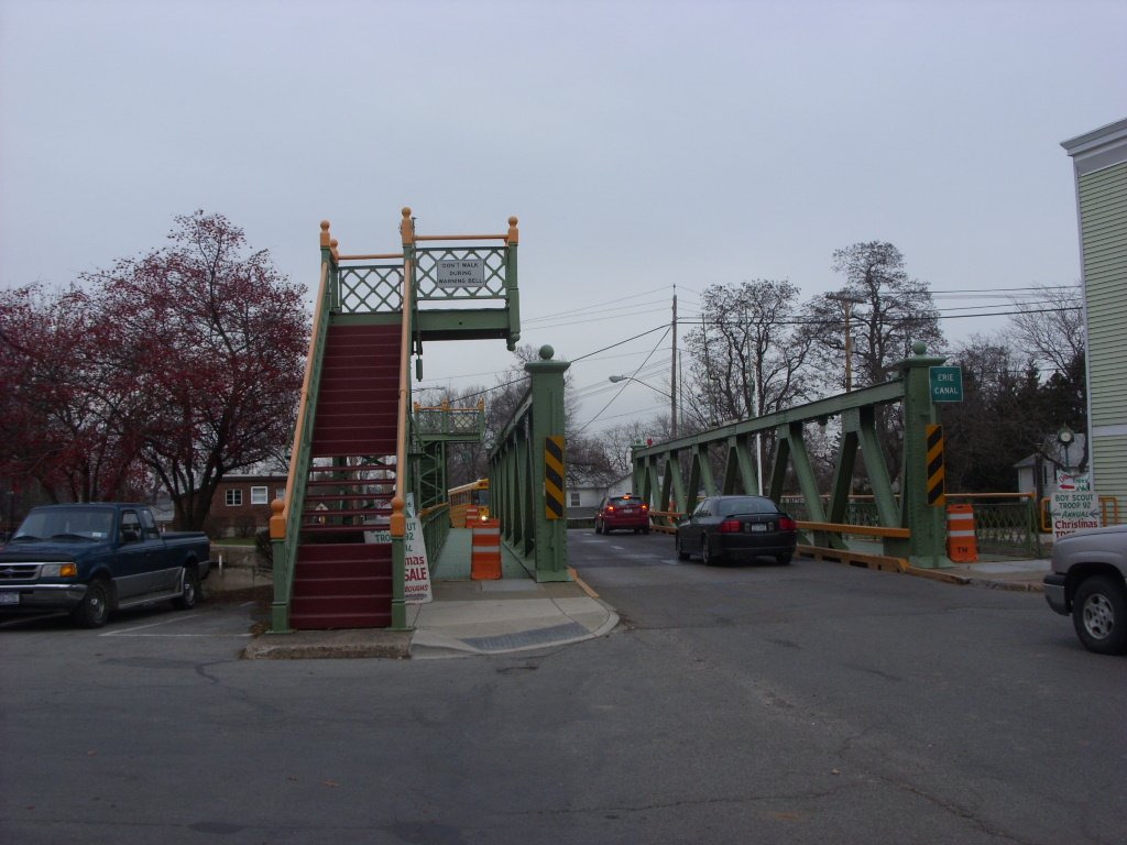
What replaces the theater of locks here is a different mechanical ritual — the raising of bridges. Because the canal runs so shallow and straight across settled farm country, the villages it passes through never sat far below their crossings; instead of arching a road high over the water, engineers hung it low and made it move. All sixteen of the Erie Canal’s movable lift bridges lie in the western third of the system, between Fairport and Lockport, and several of the best cluster right along this reach — Spencerport, Adams Basin, Brockport, Holley. When a boat approaches, the whole roadway rises on its towers, traffic stops, the vessel slides through, and the street settles back down. It is the Long Level’s substitute for a lock: not the boat lifted to meet the land, but the land lifted to let the boat pass.
Brockport wears the character best. It bills itself “the Victorian Village on the Erie Canal,” and it carries not one lift bridge but two — the Main Street span and the Park Avenue span — set so close together that a single operator has worked both, walking the short block between towers to raise one and then the other. The Main Street bridge, carrying State Route 19, dates to 1915, a product of the Barge Canal rebuild; it came through a full rehabilitation in recent years and still does the same up-and-down it has done for more than a century. A few miles east, Spencerport keeps its own bridge and its history together in a 1906 trolley depot turned canal museum, where the lower level offers restrooms and showers to boaters tied up along the free village wall.
The reach rewards an unhurried eye, which is fitting, because unhurried is its whole nature. There are no gauges to watch here, no chambers to fill, no sixty-foot walls rising alongside the hull — only the slow green corridor of the Long Level, one Victorian main street after another, and the occasional pause while a bridge climbs into the sky to let you by. It is the calmest sixty miles on the canal, and it is calm by design: the stretch where the engineers, for once, simply followed the flat and let the water drift.
In this stretch
Places to Eat
Provisions & Shops
Arriving by boat
Neither village charges to tie up, and both put real amenities right at the wall. In Spencerport you have two options: a 1,000-foot north terminal wall just east of Bridge E-174, with electric and a 48-hour limit, and a 500-foot south wall carrying both electric and water. Restrooms, showers, and WiFi are inside the Spencerport Canal Museum, the restored 1906 trolley depot that doubles as the village welcome center. Best of all, there's a free pump-out on a 50-foot dock west of the lift bridge (day-use only, no overnight). The Village Plaza supermarket and post office are a short walk from the wall.
Brockport's Welcome Center sits at Harvester Park around Mile 279, with 30-amp electric, water, WiFi, pump-out, restrooms, showers, and pay laundry — a genuine full-service stop, with SUNY Brockport and downtown just up the street. There is no fuel anywhere on this stretch; both stops are free village walls, so plan your fuel around the ends of the Long Level rather than the middle. Amenities run seasonally, so confirm in season before you count on them.
By bike & foot
This section rides the Erie Canalway Trail / Empire State Trail, and it is prime cycling country. New York names the Brockport–Rochester segment — about nineteen off-road miles of stonedust on the canal's north side — running east from Brockport through Adams Basin and Spencerport. Flat, lock-free, and family-friendly, it's the kind of towpath where you can put your head down and let the miles pass.
The Spencerport Depot and the Brockport Welcome Center both offer parking and restrooms, and the trail meets the villages at their road crossings — so it's easy to break for a coffee or a walk down Main Street and get back on the path.
By paddle
The Long Level's lack of locks is a paddler's gift: no portages, no waiting, just uninterrupted flatwater between villages. In Brockport there's an accessible dock and kayak launch at the Welcome Center, with the new pedestrian bridge and a village boathouse nearby — an easy put-in with services on hand. For the Spencerport shoreline, wall access is straightforward, though the specifics of a dedicated launch are best confirmed on arrival.
By car
Both welcome centers make good jumping-off points by car: park at the Spencerport Depot & Canal Museum or the Brockport Canalfront Welcome Center and explore on foot. The drive-in draw here is the lift bridges in action — Spencerport, Adams Basin, and Brockport all still raise their spans for passing boats — plus the depot museum and Brockport's Victorian Main Street.
Where to eat
Spencerport does its dining right on the water: Clutch on the Canal is the upscale kitchen-and-sports-bar anchor, with Grandpa Sam's Kitchen, McColley's, and a Texas BBQ Joint rounding out the walk from the wall.
In Brockport, Custom House serves waterfront dining and Stoneyard Brew & Pub pours canalside at 48 Merchants Street. For something more local, Jimmy Z's at 53 Main Street does the Rochester "plate," wings, and shakes.
Where to sleep
Brockport is where the beds are. The Hampton Inn Brockport sits steps from Main Street and the canal, near SUNY Brockport, with free hot breakfast. Best Western Brockport Inn & Suites is walkable to campus and the water, pet-friendly, with free breakfast, and the Econo Lodge Brockport is another option near the university.
For character over chains, the Park Ave Bed & Breakfast occupies a historic 1851 building blocks from Main Street. Spencerport lodging isn't confirmed this pass, so boaters overnighting there are best served by the free village wall.
What to see
The Spencerport Depot & Canal Museum — the 1908 trolley depot, restored by volunteers and open as a museum since 2007 — is the anchor attraction, telling the canal-and-community story on a seasonal schedule. But the real show is the lift bridges: Spencerport, Adams Basin, and Brockport's two spans (Main Street and Park Avenue), the latter pair worked by a single operator who walks between them.
The Brockport Main Street Lift Bridge is the headliner — a 1915 span on a 1913 lift tower, roughly 155 feet long, carrying NY Route 19, and one of only sixteen lift bridges on the entire canal, every one of them clustered between Fairport and Lockport. Nearby, the SUNY Brockport pedestrian bridge links the campus to the north side of the village.