Fairport & Pittsford
Approx. Mile 245–256 along the Erie Canal
Barge Canal · 1918 — a land cut riding the original 1822 Great Embankment. Which canal is this? →
Fairport and Pittsford are the show-stretch of the Rochester metro — two walkable canal villages built hard against the water and consistently promoted as flagship stops on the Erie Canalway. Downtown Fairport gathers around its Main Street lift bridge and Packett’s Landing harbor; four miles west, Pittsford’s Schoen Place is a restored canal landing lined with shops, restaurants, and packet-boat docks. Between them the canal rides its most famous piece of 1820s engineering — the Great Embankment, carrying the channel some 65 feet above the Irondequoit Creek valley on a man-made earthen wall.
Two pretty villages and two engineering oddities
Of all the towns the Erie Canal made, few wear the water as gracefully as Fairport and Pittsford. Their downtowns press right up against the channel; their sidewalks end at the towpath. But look past the patio umbrellas and the packet-boat crowds, and this eleven-mile reach hides two of the strangest structures on the whole canal — one a bridge that refuses to be a normal shape, the other a stretch of water that runs along the top of a man-made mountain.
The bridge that won’t sit square
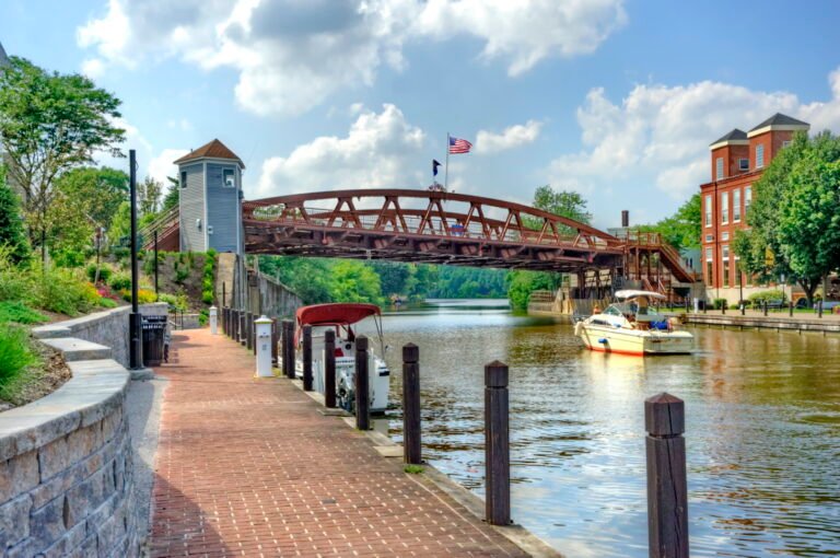
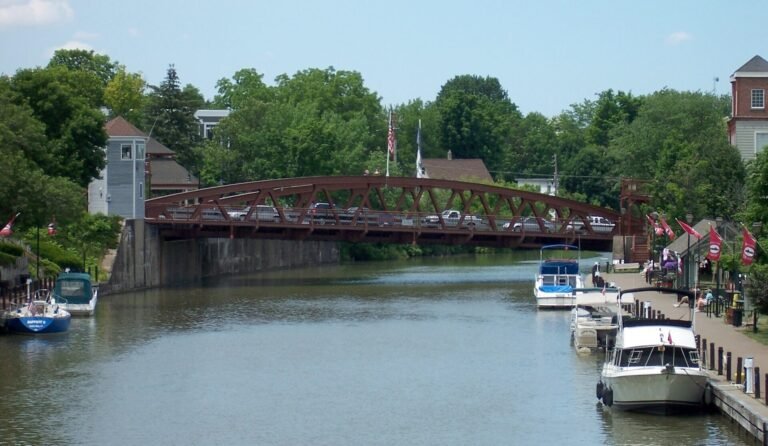
Fairport’s Main Street lift bridge is the kind of thing you keep staring at because your eye can’t quite finish it. Built in 1913–14 by the Lackawanna Bridge Company of Buffalo for roughly $75,000, it replaced an earlier fixed span pulled out when the canal was widened for the Barge era. The trouble was geometry. Main Street and the new, wider canal simply refused to meet at a convenient angle, and the land on the two banks sat at different heights. Rather than force the road to bend, the engineers bent the bridge.
The result is an irregular decagon — a ten-sided structure in which no two angles are alike and not a single corner is square. It crosses the canal on a rakish 32-degree skew, and it tilts: the south end rides noticeably higher than the north, a gentle four-percent slope built into the deck itself. Every line that should be parallel isn’t; every joint that should be a right angle isn’t. It is a genuinely peculiar piece of engineering, and Fairport is rightly proud of it.
The village is proud enough, in fact, to have wrapped it in legend. You will hear that it is the only bridge in New York built at such an angle, and that its odd geometry earned it a spot in Ripley’s Believe It or Not! Both make for a good story, and both should be enjoyed as exactly that — fond local folklore rather than documented fact. The verifiable marvel is the bridge itself: the skew, the slope, the ten sides, and the century of Main Street traffic it has carried without ever once settling into a tidy shape.
The canal that rides a ridge
Just west of Fairport the canal pulls off a quieter, older trick — one that stopped travelers cold in the 1820s and still ought to. For a stretch, the waterway does not sit in the land at all. It rides across the top of the Great Embankment, an earthen causeway that carries boats roughly 65 feet above the floor of the Irondequoit Creek valley. Passengers on the early packet boats found themselves gliding along a ridge of packed earth, water and all, looking down on the treetops of the valley below.
The idea was old before the digging started. Surveyor James Geddes, one of the canal’s pioneering route-finders, identified the crossing as early as 1808, and the embankment was completed in 1822, three years before the full canal opened. Bridging the Irondequoit valley was considered one of the original wonders of the entire enterprise — proof that Clinton’s “ditch” was as much a feat of building up as of digging down. The modern Barge Canal still follows that same made ground today. (If you’re wondering which canal you’re actually standing beside here — the hand-dug original or its twentieth-century rebuild — that’s a story of its own; see which canal is this?)
Down at the landing
The reach ends in the gentlest way possible, at Pittsford’s Schoen Place — a restored canal landing where old coal towers and freight buildings have become shops, restaurants, and a tie-up wall. From here the replica packet boat Sam Patch still pushes off for lock cruises, working the same water that once carried grain and passengers west. Two villages, two oddities, and a landing to end on: the Erie Canal at its most quietly astonishing.
In this stretch
Places to Eat
Provisions & Shops
Things to see & do
Arriving by boat
A full-service municipal stretch — walk-off dining, no anchoring required.
Village of Fairport (Packett’s Landing) is the anchor stop: transient dockage on both the north and south walls, plus added tie-up on the village’s east side, with 30-amp electric, water, WiFi, pump-out, restrooms, showers, laundry, and ice. A dockmaster is on site daily and the harbor monitors VHF 13; step off the dock and you’re in downtown Fairport.
Schoen Place, Pittsford offers canal-wall tie-up on the north side within a short walk of its restaurants and the packet-boat docks (no utilities or fuel on the wall). Lock E32 at Pittsford has a canal-park dock and launch on the north side.
One note for skippers: these are no-fuel stops, so plan your fuel legs ahead. Depths, slip counts, and fees shift seasonally — confirm with the Fairport dockmaster in season.
By bike & foot
Both villages sit directly on the Erie Canalway Trail / Empire State Trail, which the state maps as the named “Rochester–Fairport” and “Fairport–Palmyra” segments. The towpath is mostly paved asphalt from Rochester through Pittsford to Fairport, with a stretch of stone dust in the Pittsford–Fairport middle. Bike shops, parking, restrooms, and trail access cluster at the municipal parks and road crossings in both downtowns, making this one of the easiest stretches to mix boat, bike, and boot.
By paddle
The Lock 32 Paddling Center (2797 Clover St, Pittsford) rents flatwater kayaks and canoes and launches personal craft from the north-side canal-park dock; the pool below opens roughly 25 miles of flatwater. Beside it, the Lock 32 Whitewater Park runs a man-made Class II–III course through the old lock spillway — a recreation feature, not a through-route. Paddlers transiting the canal should confirm the designated portage around Lock E32 before they arrive.
By car
Municipal parking sits at Packett’s Landing in Fairport and throughout Pittsford Village and Schoen Place. Drive-in visitors come for the Fairport lift-bridge show, the Schoen Place shopping strip, and the boarding docks for the Colonial Belle and the Sam Patch packet boat.
Where to eat
Pittsford — Schoen Place: the Village Coal Tower Restaurant, a canalside diner in a former coal tower; Simply Crepes; and Lock 32 Brewing — all steps from the water.
Fairport: Donnelly’s Public House and Mulconry’s Irish Pub near the canal, plus the American Can Factory, a food-and-drink complex housing Iron Smoke Distilling, Compane Trattoria, and Triphammer Bierworks.
Where to sleep
The standout is The Del Monte Lodge, a Renaissance Hotel & Spa (41 N Main St, Pittsford; 585-381-9900) — a AAA Four-Diamond property of about 97 rooms right on the canal, with the on-site Erie Grill and a spa. Both villages also carry smaller inns and B&Bs; book ahead on summer weekends, when the canal towns fill.
What to see
Fairport Main Street Lift Bridge — the section’s signature landmark, a ten-sided span that crosses the canal on a skew with no square corners (see the history note below).
Schoen Place, Pittsford — the restored canal landing, with a towpath stroll and packet-boat docks.
Colonial Belle — the canal’s largest tour boat (149 passengers), cruising from Fairport’s Packett’s Landing west to Pittsford and Lock 32.
Sam Patch — a replica packet boat (Corn Hill Navigation) running 90-minute lock cruises from 12 Schoen Place, Pittsford.
The Great Embankment — the canal riding about 65 feet above Irondequoit Creek on the 1822 earthen wall.