Little Falls
Approx. Mile 71–83 along the Erie Canal
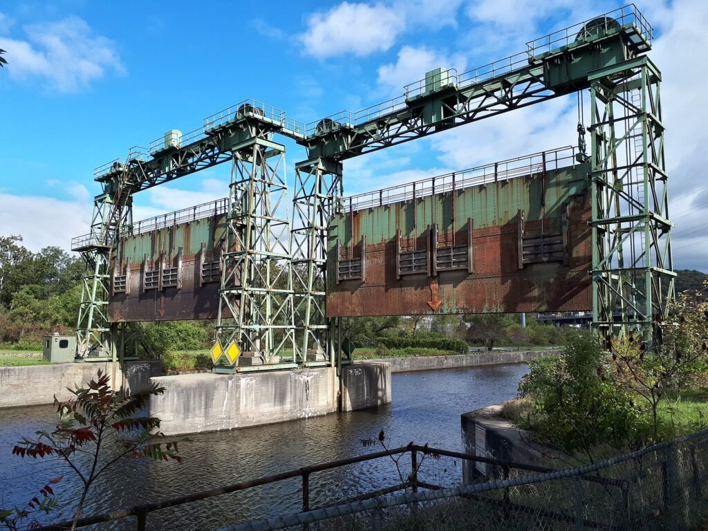
Barge Canal · 1918 — the Mohawk River gorge; three canals have climbed it since 1795. Which canal is this? →
Little Falls is the dramatic high point of the Mohawk Valley run. Here the river drops through a rock gorge, and Lock E17—with a 40.5-foot lift, the highest on the canal and once the highest lift lock in the world—carries boats past what was historically a 40-foot falls. Alongside the lock sits Moss Island, a National Natural Landmark of syenite bedrock famous for its giant glacial potholes and more than 100 rock-climbing routes.
Downtown, the National Register Canal Place district packs restaurants, shops, an arts center, and a historic-mill inn into walkable riverside blocks. This is a marquee stop—plan extra time.
The mountain pass of the Mohawk
Look at a relief map of the eastern United States and one fact jumps out: from Alabama to Maine, the Appalachian Mountains form a nearly unbroken wall between the Atlantic coast and the continent’s interior. There is exactly one place where a river cuts clean through that wall at water level — the Mohawk Valley — and the tightest, most stubborn point of that whole passage is Little Falls. Everything about this town, and arguably the entire reason the Erie Canal follows the route it does, comes down to that one geographic accident.
Here the Mohawk River abandons its broad, lazy character and knifes into a rock gorge, dropping roughly forty feet through a run of rapids in about a mile. The gorge itself is a leftover of the last Ice Age. As the glaciers melted, torrents of meltwater tore through the bedrock, scouring the walls and drilling the deep, smooth-sided potholes still visible on Moss Island beside the canal — some of them tens of feet deep, ground out by stones spun for centuries in the same swirling eddy. What the ice left behind was beautiful and, for anyone trying to move a boat, impossible.
Long before there was a canal, there was a carry. Boats coming up the Mohawk simply could not pass the falls, so cargo was unloaded, hauled overland around the rapids by wagon and muscle, and reloaded on the calmer water above — a portage economy that gave the settlement its first reason to exist. Whoever controlled the carry at Little Falls controlled the flow of freight into the interior, and a village grew up to feed, house, and tax the traffic.
The first attempt to engineer the problem away came a full generation before DeWitt Clinton’s famous ditch. In 1792 a group of investors led by the Revolutionary War general Philip Schuyler chartered the Western Inland Lock Navigation Company, and at Little Falls they cut a short canal — roughly a mile long, with a handful of small stone lift locks — to carry Durham boats around the rapids. The first boats passed through on November 17, 1795. It was one of the earliest true canals built in the United States, and it worked: for the first time, a vessel could move past the gorge without unloading a single barrel. The company itself never turned into a lasting commercial success and eventually gave way to the state’s grander plans, but it proved the principle. If locks could beat Little Falls, they could beat the whole valley. That waterway spine runs straight from the Western Inland Lock Navigation Company of 1795 to Clinton’s Ditch of 1825 — if you’ve ever wondered exactly which canal you’re looking at here, this gorge holds the answer in its layers.
When the Erie Canal proper arrived in the 1820s and climbed the same grade, and again when the twentieth-century Barge Canal drove its towering Lock E17 through the bedrock, they were only the latest engineers to take a run at a wall the first canal builders had already breached. Three canals, one gorge.
The city that grew between them got rich on freight. Perfectly placed at the pinch point where every westbound cargo had to slow, tie up, and be handled, Little Falls became a forwarding town — a place that made its money moving other people’s goods. Warehouses and mills crowded the waterfront, and one of the era’s handsomest survivals — the 1822 stone aqueduct that once carried canal boats over the Mohawk — still arches across the river near the heart of it. As the canal age matured, the town turned its hub position to specific trades, becoming a major shipping point for the Mohawk Valley’s dairy country — cheese above all — along with bulk goods rolling east toward Albany and the sea. The gorge that had blocked the river made the town that forwarded it.
Stand on the canal wall today and the whole story stacks up in front of you: glacial potholes in the rock, the ghost of the 1795 channel, and a working lock still lowering boats through the great water-level gap in the Appalachian chain. Little Falls was the hardest mile on the river for two centuries — and the most important.
In this stretch
Places to Eat
Provisions & Shops
Things to see & do
Arriving by boat
The Little Falls Canal Harbor & Rotary Park (74 Southern Ave., mile ~80) is the town's dock, and it's a good one: fixed and floating docks with roughly 10 feet of water at the approach and dockside, handling vessels up to 300 feet and offering about 12 transient tie-ups. On the wall you'll find 30- and 50-amp electric, water, WiFi, restrooms, showers, laundry, and ice, plus a pump-out ($5). There is no fuel dock here, so top off elsewhere. Confirm availability in season.
The real headline, though, is the transit itself. Lock E17 (499 South Ann Street, mile 78.99) is the only shaft lock on the Erie system, with a counter-balanced guillotine gate at the lower end that drops vertically to hold back a chamber of more than six million gallons. Locking through its 40-foot chamber is a genuine attraction, not just a passage. NYS Canals locks generally monitor VHF 13; confirm locally.
By bike & foot
The Erie Canalway Trail / Empire State Trail runs through here on the paved, off-road Little Falls–Canajoharie segment. The Canal Place and Rotary Park area is the natural trail-town hub for walkers and cyclists, with the interpretive kiosks and benches typical of Canalway stops. Confirm exact trailhead parking on the empiretrail.ny.gov map.
Moss Island is reachable on foot near the lock for hiking and climbing—an easy detour that puts you on National Natural Landmark bedrock within a short walk of the docks.
By paddle
Rotary Park / Canal Harbor rents canoes and kayaks and makes a practical launch. Be ready for the one hard obstacle on this stretch: paddlers must lock through or portage around Lock E17 and its gorge—the most significant portage on the middle canal. Moss Island sits between the river and the canal channel. Confirm the designated portage route locally before you set out.
By car
Drivers can reach every highlight. Canal Place (South Ann Street) is a drive-in historic district with restaurant and shop parking; Rotary Park / Canal Harbor offers parking for the marina and Moss Island access; and Lock E17 (499 S. Ann St.) has visitor viewing of the guillotine gate.
Where to eat
In the heart of historic Canal Place, Ann Street Deli is the hometown deli-restaurant. Nearby, the Canal Side Inn & Restaurant occupies the building that was once the regionally renowned Henry's Steakhouse; a recent ownership change may have reverted it to the Henry's name, so confirm the current name and status locally. The district also holds additional restaurants, galleries, and an Art Deco former train station repurposed as a bar and restaurant—worth a wander.
Where to sleep
The Inn at Stone Mill (410 Canal Pl., Little Falls, NY 13365) is a 10-room bed-and-breakfast on the third floor of an 1839 mill overlooking the Mohawk in Canal Place. It's adult-only, includes continental breakfast, and is bookable via major reservation sites (315-823-0208).
What to see
Lock E17 is the engineering marvel that defines this stop. Opened June 30, 1916, it did the work of four locks on the Enlarged Erie Canal, and at completion its 40.5-foot lift made it the highest-lift lock in the world. Its counter-balanced guillotine gate—the only one of its kind on the system—drops vertically to withstand the pressure of a chamber holding six million-plus gallons.
Moss Island, designated a National Natural Landmark in 1976, is metasyenite bedrock scoured into 40- to 50-foot-deep potholes by an ancestral Mohawk River that once drained the Great Lakes. Climbers know it for 100-plus routes (5.1 to 5.13), including the classic "Goat Crack" 5.2. The island itself was created when canal locks were built to bypass the roughly 40-foot falls; the original locks here date to 1793.
Downtown, the Canal Place / South Ann St–Mill St Historic District is a National Register district of renovated 19th- and 20th-century row and mill buildings—now restaurants, shops, antiques, and an arts center—revitalized with more than $1 million in public and private funds since 1987. The Little Falls Historical Society Museum rounds out the stop with local history and audio tours of Lock 17 and Rotary Park.