Crescent & Vischer Ferry
Approx. Mile 2–13 along the Erie Canal
Barge Canal · 1918 — the canalized Mohawk River between Locks E6 and E7, past preserved 1825-canal relics. Which canal is this? →
Above the Waterford Flight, the Erie Canal leaves the ladder of locks behind and settles into the wide, slow Mohawk. This section follows the river from the Crescent area near Lock E6 (around mile 2) upstream to Lock E7 and the Vischer Ferry Dam (around mile 13), threading the towns of Halfmoon and Clifton Park on the Saratoga County side and Niskayuna on the Schenectady County shore.
This is a rural-to-suburban, trail-rich stretch rather than a marina district. The Mohawk-Hudson Bike-Hike Trail — carrying the Empire State Trail along the old canal towpath — runs the length of it, and the Vischer Ferry Nature & Historic Preserve protects more than 700 acres, including an original 1825 section of the Erie Canal. It is a favorite of paddlers, cyclists, and birders, with public boat launches but few boater services.
Where the canal walked on water — and where it still holds it
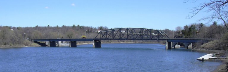
Stand on the Mohawk today, between Lock E6 near Crescent and Lock E7 at Vischer Ferry, and the river looks like the whole story: a broad, canalized channel held at navigable depth behind movable dams, the Barge Canal of 1918 flowing quietly through the valley. But the most remarkable thing that ever happened here isn’t in the water — it’s in what’s missing above it. For most of the nineteenth century, the Erie Canal did not follow this stretch of river. It crossed it. High and dry, on stilts.
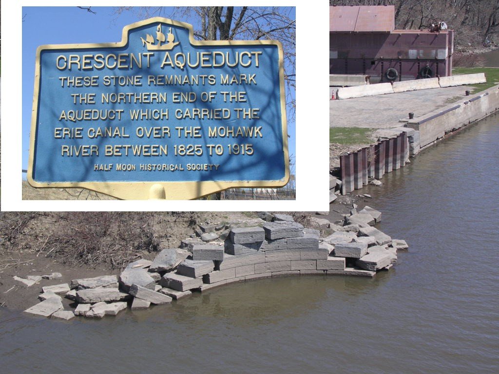
The device was the Crescent Aqueduct, and it was one of the great engineering set-pieces of the Enlarged Erie. When the canal was rebuilt bigger in the middle 1800s, the Mohawk here proved too wide and too willful to run alongside, so the engineers did the audacious thing canal builders did when a river got in the way: they carried the canal over it. The Crescent Aqueduct was a cut-stone span of twenty-six arches — a masonry trough riding on piers set into the riverbed, wide enough to float a loaded canal boat and its mules across the open Mohawk while the river ran, indifferent, underneath. Picture it: boats sailing across the sky above the water, a ribbon of engineered stone thrown clear across the valley.
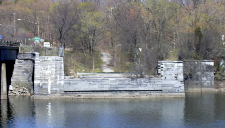
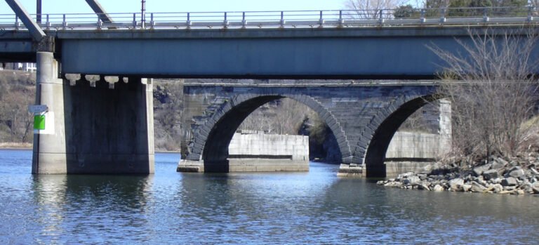
It did not survive the machine age. When the twentieth-century Barge Canal moved navigation down into the river itself — the very water the old canal had been built to avoid — the aqueduct had no job left to do. It was demolished around 1918. And here the guidebook cliché is wrong: this is not a place where you’ll find proud stone piers marching across the current. The great span’s cut stone was largely salvaged, reused into a nearby lock breakwater, its careful masonry put back to work holding the new canal instead of carrying the old one. Only scattered remnants linger on the banks. The aqueduct didn’t so much vanish as get recycled — a good New York habit, thrift dressed as demolition.
The paradox of this section is that the towpath outlasted the aqueduct. The nineteenth-century masterpiece is mostly gone; the humble dirt path the mules walked survives beautifully. Inside the 740-acre Vischer Ferry Nature & Historic Preserve, a preserved section of the 1820s Erie Canal still holds water — not a river standing in for the canal, but the actual hand-scaled ditch, quiet and green, exactly where it was dug two centuries ago. Cross it on the 1862 Whipple truss bridge, a wrought-iron span of the kind that once carried roads over canals all across the state and now survives in only a handful of places. Walk the towpath to Clute’s Dry Dock, built in 1852, where canal boats were hauled out of the water and patched — the maintenance shop of a working waterway, still legible in the earthworks. To read the old Erie as it actually lived, this is one of the best-preserved stretches anywhere on the line.
Even the modern lock here carries an antique streak. Lock E7, the Vischer Ferry lock, ran on direct current — DC power, the older and rarer standard — fed after 1925 by the Vischer Ferry hydroelectric plant across the river. Most of the canal converted to alternating current over the years; E7 was one of the last direct-current locks on the system, an electrical fossil quietly doing its work at the edge of a nature preserve.
So this section keeps a strange kind of double-time. The engineering marvel — the aqueduct that let boats fly over a river — is a ghost, its stones repurposed into the breakwater downstream. The modest stuff — a ditch, a towpath, a truss bridge, a dry dock — is what endured. If the canal in this valley has always been more than one canal at once, the ground at Vischer Ferry is where you can still tell which is which. (Not sure which canal you’re looking at from the bank? Start here.)
In this stretch
Places to Eat
Provisions & Shops
Things to see & do
Arriving by boat
Lock E6 sits physically in the village of Waterford as the fifth and final lock of the Waterford Flight, discharging into the Mohawk near Crescent — which is why some cruising guides label it "Crescent" by its river position. The lift is roughly 33 feet, and the lock grounds include a large picnic area. Upstream, Lock E7 — the Vischer Ferry Lock & Dam at the end of Lock 7 Road in Niskayuna — carries a lift of about 27 to 28 feet and is a direct-current lock powered by the Vischer Ferry Power Plant across the river.
Lock E7 Park offers a concrete boat launch about 22 feet wide, serving motorboats, canoes, and kayaks, along with picnic areas and lock-viewing. New York State Canal locks are hailed on VHF Channel 13; confirm in season with the Canal Corporation.
Boater services in this reach are genuinely thin. No fuel dock, pump-out, or transient marina wall is documented within the section itself, and the marinas near the Mohawk here are largely private boat and yacht clubs — plan to top off fuel and services downriver toward Waterford, and confirm mooring and wall availability before you arrive.
By bike & foot
The Mohawk-Hudson Bike-Hike Trail — carrying the Empire State Trail and Erie Canalway Trail — runs roughly 40 miles from the Corning Preserve in Albany through Schenectady to Rotterdam Junction, built on the old canal towpath and rail right-of-way. Its main line is paved asphalt. A scenic 15-mile ride between Vischer Ferry and Rexford strings together the Old Erie Canal towpath, Lock 7, the Vischer Ferry Historic District, Riverview Orchard, and Grooms Tavern.
Trailhead parking sits near the Rexford Bridge traffic circle, with additional parking, seating, and restrooms at Blatnick Park, Lock 7, and Lions Park in Niskayuna — Lock 7 and Lions Park also have boat launches. Inside the Vischer Ferry Preserve, a main loop of about 4.5 miles is open sunrise to sunset for hiking, nature walks, and mountain biking, with leashed dogs allowed.
By paddle
Lock E7 Park in Niskayuna is a primary paddling launch, with a roughly 22-foot concrete ramp giving kayak and canoe access to the Mohawk. The Erie Canalway water trail describes a guided 7-mile downstream paddle from Lock E7 Park to Colonie Town Park in Latham, tracing the edge of the Vischer Ferry Preserve and passing beneath the Twin Bridges.
Paddlers can lock through New York State Canal locks — life jackets required — following the Canal Corporation's guidance for boating through a lock. Rentals are available through Upstate Kayak Rentals.
By car
Lock E7 Park, at the end of Lock 7 Road in Niskayuna, offers parking, picnic areas, a boat launch, lock-viewing, and the Lock 7 Dam Overlook. The Vischer Ferry Preserve has four year-round access points: the Whipple Bridge Entrance across from Riverview and Vanvranken Roads (small lot with a bike rack); Clute's Dry Dock Entrance, about a mile east on Riverview Road; the Ferry Drive Gateway, reached via Ferry Drive just west of the Vischer Ferry General Store; and the Sugar Hill Road Extension / Vischer Ferry Power Dam Entrance at Sugar Hill and Riverview Roads, which includes the Lock 7 Dam Overlook.
Trail users can also park at the Rexford trailhead near the Rexford Bridge traffic circle.
Where to eat
The Vischer Ferry General Store at 357 Riverview Road in Rexford is the section's landmark stop — a restored 1856 general-store building housing a café that serves breakfast and lunch, coffee and espresso, and pastries, plus a gift shop and backyard seating. It is open Wednesday through Sunday, 9 AM to 4 PM; confirm seasonal hours in season.
In-section sit-down dining along Riverview Road is limited; the broader cluster of restaurants runs along Route 9 in Clifton Park and Halfmoon, a few miles north.
Where to sleep
The nearest lodging cluster sits along Route 9 in Clifton Park, a few miles north of the river, with affiliate-eligible chains. The Hilton Garden Inn Clifton Park, off I-87 next to Clifton Park Center, has an on-site restaurant and bar, fitness center, and WiFi. The Hampton Inn Clifton Park offers an indoor pool, hot tub, free breakfast, and fitness center. Also nearby are the Courtyard by Marriott Albany Clifton Park and the Residence Inn by Marriott Albany Clifton Park, the latter with an indoor pool.
What to see
The Vischer Ferry Nature & Historic Preserve — roughly 700 to 740 acres in the Town of Clifton Park, owned by the NYS Canal Corporation — is the section's centerpiece. It preserves an original 1825 section of the Erie Canal and towpath, the 1862 Whipple Truss Bridge at its main entrance, Double Lock 19 from the enlarged canal, and Clute's Dry Dock, built in 1852 on an earlier 1825 dry-dock site where canal boats were repaired. It is a designated Bird Conservation Area, home to Virginia rails, green herons, American bitterns, egrets, common nighthawks, and rusty blackbirds.
Nearby, Lock E7 and the Vischer Ferry Dam form an active lock and dam with viewing and an overlook. History runs deep here: only stone pier fragments remain of the 26-arch Crescent Aqueduct, which carried the enlarged Erie Canal over the Mohawk until its demolition in 1918, and the Rexford Aqueduct remnants sit near Aqueduct Park on the Niskayuna side. The Crescent-Church Hill and Vischer Ferry Historic Districts round out the landmarks.