Which Canal Is This? The Four Waterways Behind the Erie Canal
The Erie Canal you paddle or cruise today is not the one DeWitt Clinton opened in 1825. It’s the fourth waterway to occupy this valley — and in long stretches it isn’t a dug canal at all, but a river wearing a canal’s name.
One valley, four canals
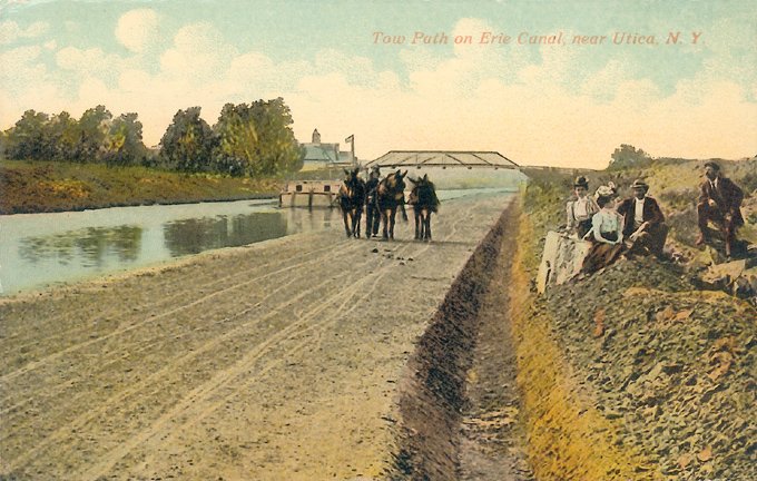
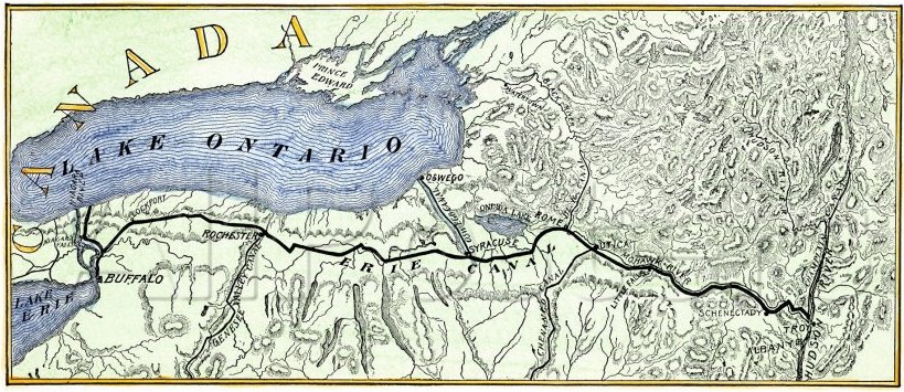
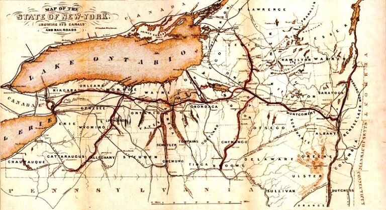
Most people carry a single picture of the Erie Canal: a narrow ditch, a mule on a towpath, a boat gliding between grassy banks. That canal existed — for about eleven years. The waterway that carries boats across New York today is its great-grandchild, the fourth in a line of canals that have occupied the same corridor for more than two centuries. Each was larger than the last, until the final version stopped digging ditches altogether and simply drowned the rivers.
This is the single most useful thing to understand about the canal, and the thing nine visitors in ten get wrong. When you stand at a lock, walk the towpath, or read a historical marker, you are almost never looking at one canal. You are looking at a stack of them — and telling them apart turns a pretty waterway into two hundred years of American ambition laid one layer over another.
Before the Erie: the little canal at Little Falls (1795)
The dream of a water road to the west was older than the United States. The first people to act on it did so a full generation before the Erie was surveyed. In 1792, a group of investors led by the Revolutionary War general Philip Schuyler chartered the Western Inland Lock Navigation Company to improve the Mohawk River route. At Little Falls in 1795 they cut a canal roughly a mile long — five small stone lift locks blasted through rock — to carry boats around the rapids where the Mohawk drops through its gorge. It was one of the earliest canals in America, and it proved, decades ahead of Clinton’s Ditch, that New York’s waterways could be tamed with locks. The little company eventually failed. The idea it demonstrated did not.
Clinton’s Ditch: the original Erie (1817–1825)
This is the canal the history books mean. Championed by Governor DeWitt Clinton against rivals who mocked it as “Clinton’s Folly,” it was dug by hand between 1817 and 1825 — 363 miles from Albany to Buffalo, and by the standards of what followed, astonishingly small: just four feet deep and forty feet wide, stepped up and down by 83 stone locks, built for perhaps $7 million. Crucially, it was a separate channel dug beside the rivers, not in them. The Mohawk and its cousins were too wild, too shallow, and too flood-prone to navigate, so the engineers dug their own tame ribbon of water alongside and let mules tow the boats along a towpath. It worked spectacularly. It cut freight costs by roughly ninety percent, poured settlers west, and made New York the Empire State. And within a decade it was hopelessly too small.
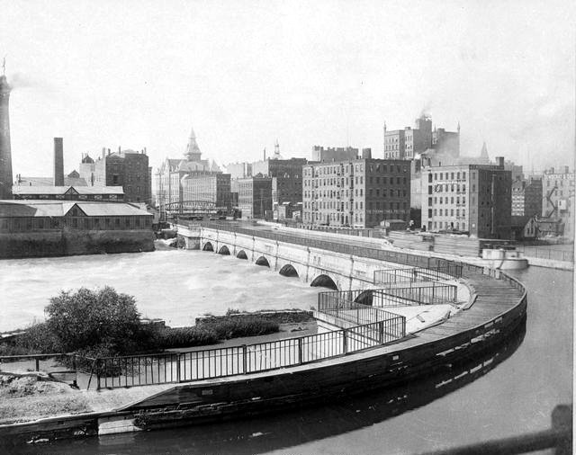
The Enlarged Erie: same idea, a bigger ditch (1836–1862)
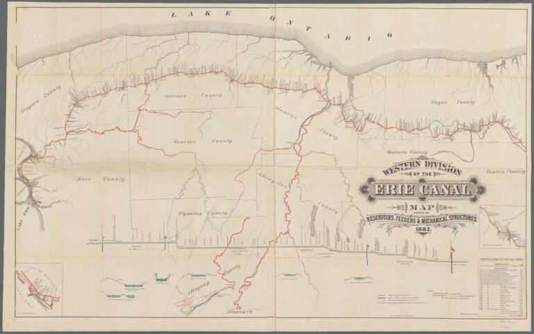
Traffic overwhelmed the little ditch almost immediately, and in 1836 New York began enlarging it — a grinding, 27-year project that deepened the canal to seven feet, widened it to seventy, and reduced the locks to 72 to pass boats of about 240 tons. It was the same concept, scaled up: still a hand-built channel running beside the rivers, still mules and a towpath. This is the canal whose magnificent stonework you actually see today when you visit the “old” canal — the doubled stone chambers of Lockport’s Flight of Five, the stranded Lock 59 at Newark, Lock 60 at Macedon, and the great aqueducts at Schoharie Crossing, Rochester, and Montezuma. When a marker says a lock dates to “1841” or “the 1840s,” it means the Enlarged Erie, not Clinton’s original.
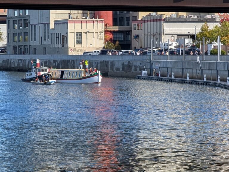
The Barge Canal: they stopped digging and used the rivers (1905–1918)
Here is the shift that changes everything. By 1900 the railroads had nearly killed the canal, and New York gambled on one last rebuild. But instead of digging a still-bigger ditch, the engineers did something radical: they canalized the rivers themselves. Rather than run a channel beside the Mohawk, they dammed the Mohawk into a chain of deep, still pools and ran the canal straight down the riverbed. They did the same to the Hudson, the Oneida, the Seneca, the Clyde, and the Oswego rivers, and threaded the route through Oneida, Onondaga, and Cross lakes. Thirty-five giant locks and a series of movable “bridge dams” — lowered each spring to pool the water for navigation, raised each winter so ice and flood can pass — replaced the old staircase of little stone chambers. Opened in 1918 and built for barges of 2,000 tons and more, it was finished just as trucks arrived to make canal freight obsolete.
The consequence is the great surprise of the modern canal. For most of the eastern third of the trip, from Waterford up the valley toward Rome, the “Erie Canal” is not a canal at all — it is the Mohawk River, held at navigable depth behind dams. A whole run of numbered “canal” locks (E8 through E15) are really river locks. The canal you boat today is often the very water the original canal was dug to avoid.
So which canal are you on?
Today’s working waterway is the Barge Canal of 1918, and once you know that, you can read the corridor like a map of its own history. Where the canal runs broad and follows a river’s bends — the Mohawk from Waterford to Rome, the crossing of Oneida Lake, the Seneca and Clyde rivers through the middle — you are riding a canalized river. Where it runs dead straight through a dug trench — over the Rome summit, along the 64-mile Long Level west of Rochester, up the climb at Lockport — you are in a true land cut, often on or beside the old alignment. And the hand-cut stone locks and aqueducts you’ll find preserved alongside the modern concrete are the ghosts of the earlier canals, kept as monuments or spillways.
Even the name is layered. From its opening in 1918 until 1992 the whole system was officially the “New York State Barge Canal.” In 1992 the state restored the historic names — Erie, Champlain, Oswego, and Cayuga–Seneca — under the umbrella of the New York State Canal System. So the “Erie Canal” on today’s charts is a name brought back from the 1825 canal and laid over a 1918 one.
On this guide, every lock and section page carries a small tag telling you exactly which waterway and which canal era you’re standing on. It’s the quiet thread that runs the length of the corridor — because the most interesting thing about the Erie Canal is that there has never been just one.
Go deeper: the three canals
Each era has its own full story on this guide:
- Clinton’s Ditch — how the original 1825 canal was built against the odds.
- The Enlarged Erie — the forgotten canal in the middle (1836–1862), and its greatest years.
- The Barge Canal — the machine-age waterway you actually boat on today (1905–1918).
Gallery
Sources
Western Inland Lock Navigation Co. (1792 charter under Gen. Philip Schuyler; Little Falls canal 1795, ~1 mi, 5 lift locks) — NPS ‘Early NY State Waterways’ + Little Falls Historical Society. Original Erie / ‘Clinton’s Ditch’ (1817–1825; 363 mi; 4×40 ft; 83 locks; ~$7M; ~90–95% freight-cost cut; a channel dug beside the rivers) — eriecanal.org + Erie Canalway NHC/NPS + History.com. Enlarged Erie (1836–1862; 7×70 ft; 72 locks; ~240-ton boats; 350.5 mi) — eriecanal.org + New York Heritage. NYS Barge Canal (1905–1918, opened 1918; canalized the Hudson, Mohawk, Oneida, Seneca, Clyde & Oswego rivers + Oneida/Onondaga/Cross lakes; ~35 locks; movable ‘bridge dams’; 2,000+ ton barges) — NPS NR nomination + American Canal Society (‘Bridge Dams on the Mohawk’) + Wikipedia ‘NYS Canal System’. 1992 rename (Barge Canal → NYS Canal System; historic names restored) — Wikipedia ‘New York State Canal System’. Surviving stone locks/aqueducts (Lockport Flight of Five, Newark Lock 59, Macedon Lock 60, Schoharie/Genesee/Richmond aqueducts) = Enlarged-Erie-era (1836–1850s) — eriecanalway.org + eriecanal.org + Library of Congress.