Rome
Approx. Mile 110–123 along the Erie Canal
Barge Canal · 1918 — the canal’s summit: the old Mohawk–Wood Creek “Great Carrying Place.” Which canal is this? →
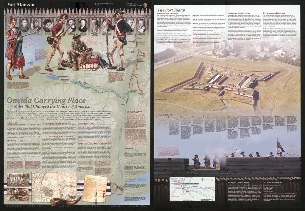
Rome earns its billing as the Birthplace of the Erie Canal: the first ceremonial shovel of dirt was turned here on July 4, 1817, and the canal has run through the city's identity ever since. It sits on the canal's summit level, near the watershed divide, so there's no lift lock to work in this stretch of water. Ashore, two landmarks anchor a visit: Fort Stanwix National Monument, a reconstructed Revolutionary War fort in the heart of downtown, and Erie Canal Village, an 1840s living-history park that recreates canal-era life.
For those arriving on the water, Bellamy Harbor Park puts you within a walk of downtown, with a transient wall, a kayak launch, and a seasonal welcome center that make Rome an easy, rewarding stop.
The mile of mud that decided a continent
For most of its length the Erie Canal was an act of engineering. At Rome it was an act of erasure. The whole enormous project — 360 miles of ditch, aqueduct, and lock — existed to destroy a single stubborn stretch of ground that had shaped North American history for a century before a shovel ever touched it: the Oneida Carry.
Look at the map the way a fur trader or a soldier once did. Everything east of here drains toward the Atlantic by way of the Mohawk River. Everything west drains toward the Great Lakes by way of Wood Creek, Oneida Lake, and the Oswego. Between the two lay a gap — one to six miles of low, wet ground, depending on the season and the mud — where a boat had to come out of the water and be dragged overland. This was the Oneida Carry, the “Great Carrying Place,” and it was the hinge of the continent. Whoever controlled that portage controlled the water route from the seaboard to the interior. It was worth an army.
So an army came. In 1758, during the French and Indian War, the British built Fort Stanwix here to guard the carry — construction directed by General John Stanwix and begun that August, finished around 1762. Two decades later it earned the nickname the National Park Service still uses. On August 2, 1777, a British force under General Barry St. Leger — regulars, German troops, Loyalists, Canadians, and Native allies — laid siege to the fort as part of the grand campaign meant to split the rebelling colonies. Inside, Colonel Peter Gansevoort’s garrison refused to yield. They held through weeks of bombardment while a relief force marched; St. Leger, hearing the relief columns approach, finally broke off and withdrew to Canada. Fort Stanwix had not surrendered — it never would — and its stubbornness helped unravel the whole British plan that ended, that autumn, in the surrender at Saratoga. The fort in downtown Rome today is a reconstruction, but the ground it stands on is the real thing.
Sixty years after the siege, a different kind of assault came to the same mile of ground — not to hold the divide, but to abolish it. On July 4, 1817, the state of New York turned the first earth of the Erie Canal at Rome, and it chose the spot deliberately: to begin where the land itself demanded to be bridged. By tradition the citizens gathered outside the village at dawn. Cannon from the U.S. Arsenal at 514 West Dominick Street sounded across the fields; the local judge Joshua Hathaway gave the opening remarks and Canal Commissioner Samuel Young addressed the crowd, and — by the old accounts — the first actual spadeful was turned by the contractor John Richardson. It is a modest scene for so large a beginning: a summer morning, a few officials, a spadeful of dirt on the exact watershed the canal was invented to conquer. The groundbreaking site, near 530 Henry Street, is industrial ground now; Rome calls itself, with justice, the Birthplace of the Erie Canal.
They started here for a practical reason, too. This flat middle section — the future summit level, where the canal crests the divide between the Mohawk and Wood Creek watersheds — was the easiest digging on the whole route, level ground with no rock gorge or escarpment to fight. Crews could learn their trade on it. The first fifteen miles, Rome to Utica, opened in 1819; the completed canal, in 1825. And here is the quiet irony a boater should carry through town: the water you travel today is not the hand-dug ditch of 1817. The modern Erie at Rome belongs to the machine-age Barge Canal of 1918, which pulled the waterway back into the Mohawk River itself — so that a boat now floats, more or less, on the very river the Oneida Carry once forced everyone to leave. The canal did what a hundred years of soldiers and traders could not. It made the carry disappear.
In this stretch
Places to Eat
Provisions & Shops
Arriving by boat
Rome's transient tie-up is Bellamy Harbor Park, paired with the Rome Navigation Center across the street. The dockage is a 200-foot fixed wall plus two short floating docks (50 and 40 feet) at the west end, tucked between bridges E-51 and E-52A. Aim for the west end: the short floating docks often fill with local boats, and the east end is reserved for canal-corporation barges, so give that side a wide berth.
One planning note that catches boaters off guard: the docks themselves have no electric and no water, and there's no fuel dock here. The trade-off is what waits across the street. The Rome Navigation Center offers bathrooms, showers, laundry, and a community room — so top off tanks before you arrive, and plan on walking over for a shower rather than plugging in at the wall. Because Rome sits on the canal's summit level, there's no lock to lock through in this section. Confirm dock availability and center hours in season.
By bike & foot
Rome is a full-fledged trail town on the Empire State Trail and Erie Canalway Trail, and Bellamy Harbor Park doubles as a trailhead — step off your boat and you're on the network. The Mohawk River Trail links the park and downtown to lodging on the edge of the city, and the through-route stitches Rome into the larger corridor between Lock 21 and Rome to the west and Rome to Utica to the east. A newer boat launch on the east side of Mill Street, just off Bellamy Harbor, adds a concrete ramp and ample parking to the mix.
By paddle
Bellamy Harbor Park has a canoe, kayak, and small-boat launch, which makes it a natural jumping-off point on the water. A classic outing here is simple and satisfying: launch at the park, paddle upstream, then let the current carry you back on the return. With no numbered lift lock in the immediate section, there's no portage to plan around close to town — just water, the tree-lined banks, and the quiet that gives the summit level its particular calm.
By car
Rome is an easy drive-in stop. Fort Stanwix National Monument sits in the heart of downtown, roughly a mile from Bellamy Harbor via Mill and Dominick Streets, with the Marinus Willett Center as its interpretive gateway; it's National Park Service-run, with free grounds. Erie Canal Village, the 1840s living-history park, is a short drive from the center of town. Parking is straightforward at Bellamy Harbor Park, including the newer Mill Street ramp lot.
Where to eat
The closest bite to the water is Coalyard Charlie's, which one boater flagged as "a short walk from the docks" at Bellamy Harbor Park — a handy anchor for a first meal ashore. Beyond it, downtown Rome opens up a wider spread of restaurants within about a mile of the docks, all reachable on foot or a short ride.
Where to sleep
The standout for cyclists and boaters alike is the Hampton Inn Rome, a "Bike Friendly NY"-certified stay reachable from downtown by bike via the Mohawk River Trail. Vacation rentals round out the options in the city. One thing to plan for: there's no campground within the City of Rome — the nearest camping is at Lock 21 (New London), about nine miles west of downtown.
What to see
Fort Stanwix National Monument is the marquee stop — a reconstructed fort that recreates the British siege of 1777, backed by hundreds of thousands of artifacts and the Marinus Willett interpretive center. Erie Canal Village carries the story into the canal era, an 1840s-period museum park that interprets everyday life along the young waterway. And Bellamy Harbor Park itself is a piece of the history it serves: a canal-heritage site with docks and a kayak launch, a fitting place to stand where the Birthplace of the Erie Canal meets the modern channel.