Waterford
Approx. Mile 0–3 along the Erie Canal
Erie mile 0 · Barge Canal — where the canal climbs from the Hudson into the Mohawk by the Waterford Flight. Which canal is this? →
Waterford is where the Erie Canal begins. At Mile 0, the canal officially opens at the confluence of the Hudson and Mohawk rivers — and it is here, too, that the Champlain Canal branches north toward Lake Champlain. Four navigable waterways meet at one point: the Hudson, the Mohawk, the Erie heading west, and the Champlain heading north. For a boater working the system, this is the crossroads.
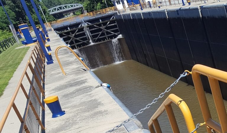
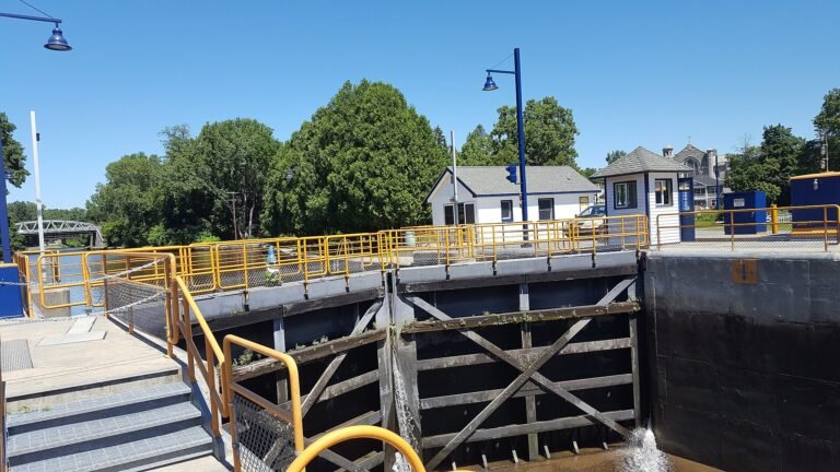
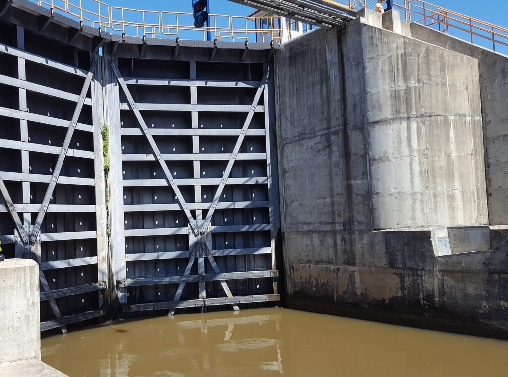
The village’s signature is the Waterford Flight of Locks — five consecutive locks, E2 through E6, that lift vessels roughly 169 feet in about a mile and a half while bypassing Cohoes Falls. It is widely described as the highest lift in the shortest distance of any canal system in the world, a claim the Waterford Historical Museum itself frames more cautiously as speculated rather than settled. Either way, the climb out of Waterford is one of the great set pieces of American inland navigation.
Waterford also claims to be the oldest continuously incorporated village in the United States, chartered on March 25, 1794. The Waterford Harbor Visitor Center is the practical hub for everyone passing through — boaters, cyclists, and walkers alike.
Most places on a map are somewhere on the way to somewhere else. Waterford is where the ways themselves come together. Set on a spit of land where the Mohawk River empties into the Hudson, this small village north of Troy is one of the great knots in North America’s inland navigation — the single point where four waterways meet. The Hudson runs down from the Adirondacks toward the sea. The Mohawk arrives from the west, draining the only water-level gap through the Appalachian barrier. And here the two canals that used those rivers split apart: the Erie Canal turns west up the Mohawk toward Buffalo and the Great Lakes, while the Champlain Canal strikes north toward Lake Champlain and, beyond it, Canada. Stand on the harbor wall and you are standing at a genuine crossroads — not a figure of speech, but four directions of open water leaving from one spot.
That the Champlain Canal begins here too is easy to miss and worth pausing over. Opened on September 10, 1823 — two years before the Erie was finished — it runs some sixty miles north to Whitehall at the foot of Lake Champlain, opening a water route toward Montreal. For the boater it means Waterford is a fork in the road: west to the Lakes, or north to the border. For the historian it means this modest village was, for a time, the hinge on which the whole northern reach of American commerce turned. Which canal is this? At Waterford, the honest answer is both at once.
The village beneath the junction is older than either canal. Waterford bills itself as the oldest continuously incorporated village in the United States, chartered on March 25, 1794 — a full generation before the diggers arrived to make it a port. The site had already been a crossing for centuries: known in the colonial era as Half Moon Point, it sat at the fordable shallows the Mohawk breaks into as it nears the Hudson. Those same shallows gave the place its later name, and its earliest strategic weight.
You can still walk to the evidence. At the Mohawk’s mouth lies Peebles Island, today a state park of quiet trails and river overlooks — but in 1777 it was chosen to be a battlefield. As a British army pushed south down the Hudson that summer, Patriot General Philip Schuyler picked Peebles Island for his final stand in the defense of Albany, throwing up earthen breastworks on the high ground commanding the fords. General John Glover’s guns waited there. The blow never landed: when Horatio Gates took command, he marched the army north instead, to meet the British at Saratoga and win the war’s turning-point victory. The fortifications were never tested — and so they survive. Two and a half centuries on, you can trace the low grassy ridges of those breastworks along the island’s footpaths, some of the oldest military earthworks you will find anywhere on the canal.
The park complex holds a second layer of the story, this one made of steel and river-water rather than powder. On neighboring Van Schaick Island in Cohoes — today folded into the same Peebles Island State Park complex — stands the Matton Shipyard, founded by John E. Matton in 1916 — the very year New York’s machine-age Barge Canal was completing — and it spent the twentieth century building the working boats that canal demanded: canal barges, tugs, police boats, even submarine chasers for the Navy in the Second World War. It launched its last hull in 1983. Now owned by the state and folded into the park, the yard is becoming a museum of canal boatbuilding, with the historic motorship Day Peckinpaugh tied up at its berth — a rare surviving canal freighter, resting where such vessels were once born.
That heritage still comes alive on the water. The Waterford Harbor Visitor Center anchors a free tie-up wall at mile zero, and each year, on the weekend after Labor Day, tugboats churn in from up and down the system for the Waterford Tugboat Roundup — a gathering of working and retired canal tugs that fills the harbor with diesel, whistles, and crowds. It is a fitting ritual for the place: the spot where all the waterways knot together, throwing a party for the boats that ran them.
In this stretch
Places to Eat
Things to see & do
Arriving by boat
The Waterford Harbor Visitor Center is the eastern terminus tie-up, sitting at Mile 0 at the base of the Flight. It is a free municipal wall, and it fills fast — on summer weekends the floating docks book up early, so plan an early arrival. Depth runs about 14 feet, and the harbor accommodates vessels up to 150 feet.
There are two places to lie. A 1,000-foot floating dock west of the bridge carries 30A and 50A shore power (about $10/day), water, showers, and WiFi. A 600-foot concrete wall east of the bridge is a 48-hour maximum with no power or water — a straightforward overnight hold. Confirm current fees and services in season.
A pump-out is reported nearby; confirm on-site. There is no fuel dock at the visitor center — top off before you arrive or plan your fuel stop elsewhere on the run. For lock operations, NYS Canals monitors VHF Ch. 13, but confirm the harbor’s hailing arrangement with the visitor center directly. And note the geography before you commit a route: this is where the Erie and Champlain canals split, so westbound and northbound crews part company right here.
By bike & foot
Waterford is a genuine trail hub on the Empire State Trail, and the Champlain Canalway Trail begins here, running north toward Halfmoon. The first half-mile or so out of the village is an on-road stretch following local streets, with visitor services close at hand; from there the off-road segment — roughly 5.5 miles — is a stonedust surface that suits walkers and cyclists of all abilities.
The trailhead sits near the intersection of 5th Street and Route 32 (Broad Street); watch for signage. Free parking is available at the Waterford Visitor Center. If you cross to Peebles Island, note that parking there runs $6 per car on weekends, with a walking lane on the bridge from the visitor center.
By paddle
For paddlers, the launch point is Peebles Island State Park / Waterford Point, at the confluence of the Hudson and Mohawk. The park has a large headwall and floating docks built for motorized boats, so paddlers are steered instead to park and put in at the First Street parking area (Waterford Point). Upstate Kayak Rentals has operated at the launch supplying paddling gear; confirm current-season operation before counting on it.
One caution: the Waterford Flight is a working commercial lock system, and there is no confirmed paddler portage route around the E2–E6 climb. Treat the Flight as infrastructure to plan around, not through, and check locally before attempting any passage.
By car
Arriving by car, the Waterford Harbor Visitor Center offers free parking and drive-in access to the harbor promenade and Lock E2 Park — the easiest way to watch the Flight in action from shore. Just across the water, Peebles Island State Park charges $6 per car for weekend parking and opens its visitor center seasonally; the park delivers trails and overlooks above the rivers and rapids at the confluence.
Where to eat
Two Broad Street mainstays sit within an easy walk of the harbor. McGreivey’s Restaurant (91 Broad St) serves New American fare — steak and seafood — with an attached pub, in a building that dates to 1876 as McGreivey’s Northern Hotel. For breakfast and diner comfort food, Don & Paul’s Coffee Shop (68 Broad St) is the classic morning stop. Hours shift seasonally at both; confirm before you walk over.
Where to sleep
There is no lodging confirmed inside Waterford village itself; the nearest cluster of chain hotels sits a few miles south around Troy and Cohoes. Reported options in that corridor include the Hilton Garden Inn Troy, the Courtyard by Marriott Albany Troy/Waterfront, and the Best Western Plus Franklin Square Inn Troy/Albany. Confirm distances, amenities, and availability directly.
What to see
The headline attraction is the Waterford Flight of Locks (E2–E6) — five locks lifting roughly 169 feet over about a mile and a half, bypassing Cohoes Falls. The Flight opened to navigation on May 15, 1915, as the first major operational segment of the New York State Barge Canal, following construction that began around 1905. Watching a boat climb the Flight is the single best reason to linger in Waterford.
Around it: the Waterford Harbor Visitor Center and Promenade with adjacent Lock E2 Park; the Waterford Historical Museum and Cultural Center, which keeps the canal’s interpretive story; and Peebles Island State Park at the Hudson–Mohawk confluence, with trails, rapids overlooks, and a deep industrial-mill history. The Waterford Village Historic District is listed on the National Register.
Time your visit for the Tugboat Roundup — held the weekend after Labor Day and anchored at Lock E2 Park — and the harbor becomes a gathering of working boats, one of the canal’s signature annual events.