Canajoharie & Fort Plain
Approx. Mile 45–65 along the Erie Canal
Barge Canal · 1918 — the canalized Mohawk River, in bridge-dam country (Locks E12–E15). Which canal is this? →
Here the canal settles into the middle Mohawk Valley, threading a chain of old canal villages through Palatine German farm country in Montgomery County. Fonda, the county seat, Canajoharie — company town of the Beech-Nut baby-food works and home of the Arkell Museum — and Fort Plain each grew up on canal traffic, and their downtowns still lean toward the water.
The marquee landmark stands just downstream at Fort Hunter, where the ruins of the Schoharie Aqueduct — fourteen stone arches raised during the canal's 1839–41 enlargement — still stride across Schoharie Creek at the Schoharie Crossing State Historic Site. Four low-lift locks, E12 through E15, step boats gently through the corridor as the channel follows the river past fertile bottomland.
The rivers that had to cross rivers
Here is the problem no one warns you about when they tell you the Erie Canal was a ditch. A canal is a river the engineers built themselves — a ribbon of still water held at one careful level so a mule can tow a boat along it. But the land the Erie crossed was already laced with rivers of its own: the Mohawk, the Genesee, the Seneca, and a dozen lesser creeks, each one a moving trench of water cutting straight across the path. When two rivers meet, they simply mix. But a canal cannot mix. Let the Schoharie’s spring flood pour into the canal and you lose your level, your boats, and your whole enterprise. So the engineers did the most audacious thing in the entire system. They carried the canal over the river — boats and mules and towpath and all — on a bridge built to hold a river in the air.
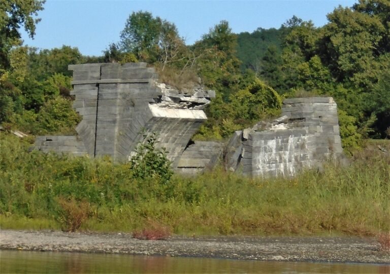
The grandest of these crossings stands in ruins at Fort Hunter, where the Schoharie Creek runs down to meet the Mohawk. When New York enlarged its original hand-dug canal in the 1830s, engineers threw a masonry aqueduct across the creek here: fourteen stone arches, 624 feet of cut stone, a watertight stone trough riding on piers with a towpath running beside it. Construction began in 1839 under the contractor Otis Eddy and finished in 1841; boats began crossing the creek on it in 1845. State officials called it perhaps the single greatest improvement of the whole enlargement — and stood on the bank to watch canal boats float serenely across the top of a river that would have drowned them a few feet below.
It did not survive whole, and the way it came apart is its own slow drama. The aqueduct carried boats until 1916, when the Barge Canal moved traffic into the rivers themselves and left the great stone span with no purpose but to stand there. In the 1940s the U.S. Army Corps of Engineers deliberately demolished the six easternmost arches — not out of neglect but to break up the ice jams that piled against the piers each spring. Then time and water took the rest by ones: a seventh arch collapsed in a 1977 flood, and an eighth fell on August 16, 1998. Of the original fourteen, six arches still stand — a broken stone colonnade marching partway across the creek and stopping in mid-air, the most ambitious ruin on the whole canal.
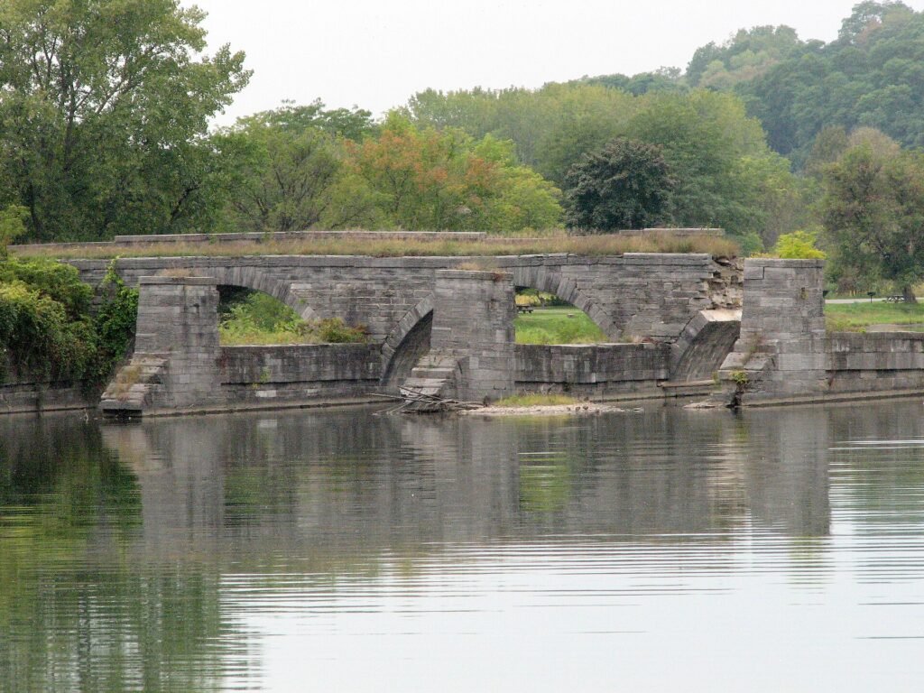
Fort Hunter was not alone. The great aqueducts were a family, and each one met a different fate. At Rochester, the canal crossed the Genesee River twice; the surviving span — built 1836 to 1842, credited to Nathan Roberts, the same self-taught engineer who conjured Lockport’s Flight of Five — still stands downtown, but you would never guess its origin. In 1927 the city laid a roadbed across its old canal trough and renamed it the Broad Street Bridge, and for three strange decades it hid the abandoned Rochester Subway inside the channel that once carried boats. West of the Finger Lakes, the Richmond Aqueduct vaulted the Seneca River near Montezuma on thirty-one arches across some 840 feet — the second-longest aqueduct on the canal — built 1849 to 1857 and partly torn down in 1917 to give boats a clear run of the river; ten arches survive, seven on one shore and three on the other, a stone bridge to nowhere in the marsh.
Stand below any of them and the audacity lands. A river, held in a stone box, floating over another river — with mules walking a path beside it and boats gliding across the sky. It remains, two centuries on, the single most astonishing idea in a canal full of astonishing ideas: that the way past a river was not around it or through it, but above it.
In this stretch
Places to Eat
Provisions & Shops
Things to see & do
Arriving by boat
The friendliest tie-up in this stretch is Canajoharie's Riverfront Park, a terminal wall on the south shore of the Mohawk just east of Lock E14. Waterway Guide's listing describes in-river floating docks for roughly four boats with free 30-amp power — an inviting stop within walking reach of downtown and the Arkell Museum — though the free-dock status is worth a quick confirm in season before you count on it.
Downstream, Lock E15 sits at Fort Plain, once a major canal shipping point; specific dock and wall amenities there, and at Fonda, aren't documented here, so plan to confirm them locally. We have no verified fuel, pump-out, depth, or VHF details for any of the three villages — treat those as open questions and check in season. The locks themselves are easygoing: E12 (Tribes Hill) lifts 11 feet, and E13 (Yosts), E14 (Canajoharie), and E15 (Fort Plain) each about 8 feet.
By bike & foot
The Erie Canalway Trail, carried here by the Empire State Trail, runs paved and off-road through the section. The Canajoharie-to-Amsterdam segment covers about 22 paved miles, with visitor services in Canajoharie and Fultonville and none in between — so top off water and snacks before you set out. There's public parking at the Schoharie Crossing State Historic Site in Fort Hunter if you'd rather ride out from the aqueduct.
By paddle
This reach belongs to the NYS Canalway Water Trail and the Erie–Mohawk Historic Water Trail. The floating docks at Canajoharie Riverfront Park are a plausible launch or take-out, though hand-launch suitability is worth confirming on site. Locks E12 through E15 require portage; the specific carry routes around them aren't documented here, so scout ahead before you commit to a paddling day.
By car
By road, the anchor is Schoharie Crossing State Historic Site, whose museum and visitor center at 129 Schoharie Street, Fort Hunter keeps a seasonal May 1–October 31 schedule, with parking on site. In downtown Canajoharie, the Arkell Museum is an easy drive-in stop. West of Fonda, on the north bank of the Mohawk, the Saint Kateri Tekakwitha National Shrine sits about a quarter-mile from the village.
What to see
The Arkell Museum at Canajoharie is the surprise of the valley: a serious collection of American painting — Gilbert Stuart, Robert Henri, Winslow Homer among the roughly 1860–1940 holdings — alongside Mohawk Valley history and a Beech-Nut advertising archive. It grew from the Canajoharie Library & Art Gallery founded by Beech-Nut's first president, Bartlett Arkell; the museum building broke ground in 1927.
At Fort Hunter, Schoharie Crossing State Historic Site — an Erie Canal National Historic Landmark — preserves the ruins of the 624-foot-3-inch Schoharie Aqueduct (fourteen stone arches, 1839–41) plus a 3.5-mile stretch of original canal at the Mohawk–Schoharie confluence. Upstream, the Fort Plain Museum & Historical Park spreads across about 75 acres on the site of Revolutionary War Fort Plain (built 1779), with an excavated blockhouse site and its own section of the Erie Canal.
Near Fonda, the Saint Kateri Tekakwitha National Shrine & Caughnawaga Village Site honors the first Native North American saint; its grounds hold the only fully excavated Iroquois/Haudenosaunee village, rediscovered in 1950 and listed on the National Register. Just outside Canajoharie, the natural gorge and pothole known as "The Boiling Pot" at Wintergreen Park is a local curiosity worth confirming details on before a visit.